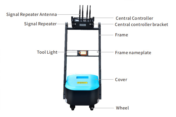
The dipole profiles in the piezoelectric water finder developed by the PQWT ground water detector institute are colorful, colorful diagrams divided by a number of contour lines of equal value. The question is often asked, what do the different colors represent? Which color represents water? Answering this question requires starting at the beginning.

The right side of the profile has a row of color bars (also called numerical value bars), the top is red, from top to bottom in accordance with the order of red, orange, yellow, green, blue and blue is divided into 18 blocks of color, in each piece of color next to the block is marked with a number, the number indicates that this color represents the value of this interval of the difference in potential value is how much, the top piece of the number marked out on behalf of the figure of the difference in the potential of the maximum number is how much, the 18 blocks of color will be divided into the maximum value of the maximum value of 17 The 18 color blocks divide this maximum value into 17 equal parts, according to which the upper and lower limits of the potential difference represented by each color block can be calculated. If the maximum value is 2.30, 2.30 / 17 = 0.14, then the bottom of a dark blue block represents the potential difference that is 0.00 ~ 0.14, and so on analogous to the penultimate block that is 0.14 ~ 0.28, the value of each color block are calculated in this way.
From the above, it can be seen that the values represented by each color block of the ground water detector are determined by the maximum value in the graph. If the maximum value changes due to a change in signal strength or interference on the same line, the values represented by each color block will also be adjusted. When the maximum value increases a lot, the color of the other measurement points will change in the direction of blue and appear more blue, even though the value of the other measurement points does not change. When the high values are lowered on the computer these points change again in the direction of red. It follows that the proposition of what color represents water is not valid.
In the same ground water detector plot, the color and value indirectly reflect the nature of the rock, i.e., the difference in the mineral composition of the rock and its water content. The closer the rock is to the red color, the more likely it is to conduct electromagnetic waves, and the closer the rock is to the blue color, the more likely it is to absorb electromagnetic waves. There are many factors affecting the size of the rock value, the closer the red color means the harder the rock is, or the less clay minerals or black minerals there are, or the smaller the fracture rate is, etc., and the closer the blue color, the opposite is true. The more factors affecting the size of the rock value, the more there are multiple interpretations, which is the multiplicity and complexity of the electrical exploration.
Rock categories and mineral composition are very different, the depth of different lithology is also different, so in the ground water detector map is neither the redder the better, nor the bluer the better, the principle of finding water is to be in the horizontal or vertical, from the unchanged in the search for mutation, from the small change in the search for large changes, in the red in the search for blue, in the blue in the search for reddish. Or to look for the contact zone between the two. This is usually referred to as geological anomalies, the anomalies mentioned here include both abnormal changes in color and abnormal changes in contours, such as the density of the contours of the sudden change, or jagged, folded line, V-shaped, inverted V-shaped and other forms. Observation of anomalies should be based on horizontal observation, supplemented by vertical observation, with 0 gain measurement of the original map, supplemented by processing the map (processing the map can only look at the contour lines, the color and value can not be too much attention).
Tectonics can control water, lithology can also control water, brittle and hard rocks have higher well formation rate than soft rocks, some people call it lithology water control theory. The greater the range of bluish color in the graph (also depends on the value of the color block), the greater the possibility of bad lithology, bad lithology fissures are not developed, the water is not good. If the range of bluish color in the reddish map is localized, for example, in the form of small clusters, narrow columns, or alternating thin layers, the likelihood of lithological changes is much smaller, and the likelihood of increased fracture rate is much larger.
It is also common to look for reddish areas in ground water detector maps that are predominantly bluish to locate wells. For example, looking for gneiss in rocks dominated by schist, gravel in rocks dominated by mudstone, and marble in rocks dominated by hornblende are all examples of looking for reddish areas in a bluish map. These reddish areas have good lithology and the fissures will be a little more developed. At this point, the positive incremental effect of lithology on the value greatly masks the negative incremental effect of fissures on the value, so in this case it is better to choose the reddish area to drill the well.
What color is the Quaternary gravel layer in the upper part of the diagram? This depends on whether the Quaternary underlies a high or low value formation. If it is underlain by a very low value mudstone, the gravel layer is reddish, and a well should be drilled in a shallow reddish area with a large thickness and a deep color to find sandy water.
If the gravel layer is underneath the high value of the rock, due to the sand layer porosity large water content, the gravel layer will often be blue with the weathering zone of the rock together.
The maximum value also becomes larger as the survey line approaches the high voltage line. The larger the maximum value, the value of each color block is correspondingly larger, even the value of the blue color block will be larger, so you can not just look at the color of the map, but also look at the size of its value. A few diagrams with flying points, the maximum value is caused by interference, must be distinguished. The maximum value of the profile in theory can be very large, in the absence of interference in the case of tens or hundreds are normal, different manufacturers of instruments measured the size of the value is not the same. In the case of the pqwt ground water detector, some of the maximum value reaches 222, and the amount of water is still very good. In some cases, the value of hard rock in the horizontal stratification graph is as high as 4061, but it is in great contrast to the upper and lower values, and the water output reaches 70 to 80 cubic meters per hour. There are also those measured on harder granite in remote areas that are all in the 0.0's and have good water volumes. This is very illustrative, the value of large and small and the presence of water is not directly related to the absence of water. In the chert formation, the values are mostly small because of the hardness of the water, which is also caused by the high mineral content of the water or the high fracture rate or even mud seams. It should also be noted that the value measured by the tensiometer is not a concept with the potential difference measured in the man-made field and is not comparable.
What is the cause of the white color in the graph? The white color indicates that the measured value is 0. The color next to the 0 value is generally the dark blue at the bottom of the color bar, and the numbers marked in this dark blue are all 0.00~××. It can be assumed that the white color and the dark blue at the bottom are the same color area, and the presence of a 0 value is mostly normal. The presence of white areas will not affect other areas, if after retesting the 0 value disappeared, but still in the dark blue area, is also normal. Appearance of 0 value of the figure hit a good water is not rare, the amount of water size is not related to the 0 value.
How can the black diamond-shaped block in the figure be interpreted? In the profile often see some with a black border up the small rhombus or triangle, in the curve such points are undoubtedly the value of particularly high discrete points. These points are flying out of the normal range of the curve and can be called flying points. The cause of the flying points are the result of unexplained interference, and often disappear or displacements when retesting. Some charts have hit water with such a flyspot as a target without retesting, but this is only a coincidence, and it is very unlikely that water will come out at the depth that the flyspot responds to.
The black edge of the flyspot is because its value is so high that the contour lines sketched along its perimeter are very dense, so it becomes black, just like the case of a steep hill encountered when plotting the contour lines of the terrain is the same situation. The black horizontal stripes in the figure are either real horizontal height layers or perverted flypoints, which should be recognized.
The values of the flying points framed with black borders will not affect the values and colors of the points outside the black box, and can be deleted without affecting the analysis of the map. However, more flying points indicate more interference. Most of the star-shaped points without black edges are also caused by interference, and it is worth considering whether the values are reliable.
The distribution of blue and red areas up and down in the diagram is also a common pattern. The upper part of the graph is a blue color with a large thickness and no obvious information, only in the lower part is reddish, but with a large depth. This situation does not mean that the upper part is necessarily waterless, it is just more difficult to distinguish. If the value is not very small and it is a crystalline rock, you can find the edge of the relatively high value point from the treatment map to set the well location, and use the more brittle and hard rock measurement point to drill the well.